
13 Hidden Gems in the Upper Peninsula
Would you like to save this full guide?
We recently asked, “What’s the most surprising or unexpected destination you’ve stumbled upon in Michigan?” And we were excited to see so many great hidden gems in the Upper Peninsula in the responses!
Here are a few of our favorite Upper Peninsula hidden gems that don’t get enough love (in our humble opinion)…

Canyon Falls
Canyon Falls, often referred to as the “Grand Canyon of Michigan,” is a stunning natural feature located in the Upper Peninsula. This beautiful site is situated along the Sturgeon River in Baraga County, near the town of L’Anse.
The falls are a highlight of the rugged and scenic landscape that characterizes much of the Upper Peninsula, offering visitors a glimpse into the area’s geological history and natural beauty.
The Falls
Canyon Falls itself is a series of cascades and rapids, with the main drop being quite dramatic. The water flows through a narrow, canyon-like gorge carved into the ancient bedrock, creating a picturesque scene that draws photographers, nature enthusiasts, and hikers.
Hiking Trail
There is a well-maintained trail leading to Canyon Falls that is accessible for visitors of all ages. The trail is approximately 1 mile long and offers various viewpoints of the falls and the surrounding gorge. Along the way, hikers can enjoy the lush forest, the sound of rushing water, and potentially spot local wildlife.
The “Canyon”
Beyond the main falls, the river continues to flow through a deep, narrow canyon with steep, rocky walls. This part of the gorge emphasizes why the site is likened to a mini Grand Canyon, albeit much smaller and covered in dense forest.
Accessibility
Canyon Falls is easily accessible from US-41, south of L’Anse, Michigan. There is a roadside park that serves as the trailhead to the falls, complete with parking, picnic areas, and restrooms, making it a convenient stop for travelers exploring the Upper Peninsula.

Agate Beach
Agate Beach is located on the shores of Lake Superior near Grand Marais Michigan. It is a charming destination known for its scenic beauty and unique geological features. This beach is a favorite spot for rock hounds, nature lovers, and those seeking a serene escape by the lake.
Agate Hunting
As the name suggests, Agate Beach is a prime location for finding agates – semi-precious gemstones formed in volcanic rock. These stones are known for their intricate patterns and beautiful colors. Visitors to the beach often spend hours combing through the pebbles along the shoreline, searching for these geological treasures.
Scenic Beauty
The beach offers stunning views of Lake Superior, the largest of the Great Lakes. The expansive views of the water, combined with the rugged beauty of the Upper Peninsula’s coastline, make Agate Beach a picturesque destination.
Recreation
Apart from agate hunting, the beach and surrounding areas are popular for hiking, picnicking, and photography. The natural setting provides a peaceful backdrop for these activities, allowing visitors to enjoy the outdoors and the region’s beauty.
Nearby Attractions
Agate Beach is close to other natural and historical attractions, including Pictured Rocks National Lakeshore, Sable Falls, and the Log Slide Overlook. These sites offer additional opportunities for hiking, sightseeing, and exploring the unique landscapes of the Upper Peninsula.

Sable Falls
Sable Falls is one of the many natural wonders found in the Upper Peninsula of Michigan, located near the eastern end of the Pictured Rocks National Lakeshore, close to the town of Grand Marais. This beautiful waterfall is part of the Sable Creek as it makes its way to Lake Superior, tumbling over a series of sandstone steps and shelves.
The falls are surrounded by lush forest, making it a picturesque spot for visitors seeking the tranquility of nature and the beauty of Michigan’s landscapes.
The Waterfall
Sable Falls cascades down approximately 75 feet through layers of Munising and Jacobsville sandstone, creating a stunning visual display. The waterfall is divided into several drops, with the largest single drop being about 20 feet. The sound of the water, combined with the serene forest setting, makes for a peaceful and memorable experience.
Hiking Trail
Access to Sable Falls is facilitated by a well-maintained trail and staircase that leads visitors from the parking area to the falls. The trail offers several viewing platforms, providing different perspectives of the falls and the opportunity to take in the scenic beauty of the surrounding area.
Nearby Attractions
Sable Falls is just one of the many attractions within Pictured Rocks National Lakeshore. Others include the Grand Sable Dunes, the Log Slide Overlook, and the Au Sable Light Station. The area is also known for its stunning hiking trails, including the North Country Trail, which offers breathtaking views of Lake Superior and the park’s unique geological features.

Log Slide Overlook
The Log Slide Overlook is a remarkable natural attraction within the Pictured Rocks National Lakeshore in the U.P., near Grand Marais. This site offers a window into the region’s logging history and breathtaking views of Lake Superior, the Grand Sable Dunes, and the surrounding forests.
Historical Significance
The Log Slide got its name from its historical use by loggers in the late 19th and early 20th centuries. Logs cut from the surrounding forests were sent down the steep slope to Lake Superior, where they were then floated to nearby mills. Although the original log slide is no longer there, the area is steeped in the history of Michigan’s lumbering era.
Spectacular Views
The overlook provides one of the most stunning vistas in the Pictured Rocks National Lakeshore. Visitors can see for miles across Lake Superior, with the Grand Sable Banks to the east and Au Sable Point to the west. On clear days, the view is unparalleled, offering photo opportunities and the chance to see freighters passing in the distance.
Grand Sable Dunes
The dunes near the Log Slide are part of the Grand Sable Dunes system, which rises hundreds of feet above the lake level and spans several miles along the coast. These dunes are a dynamic landscape, constantly shaped by the wind, and their scale and beauty are a highlight for many visitors.
Hiking Opportunities
There are several trails around the Log Slide Overlook, including paths that lead to the dunes and others that explore the surrounding forest and coastline. These trails offer a range of hiking experiences, from easy walks to more challenging treks.

Roadside Parks on Lake Superior Near Copper Harbor
Roadside parks along Lake Superior near Copper Harbor provide visitors with stunning views of the lake, picnic areas, and access to natural and historical sites. While Copper Harbor is at the northern tip of the Keweenaw Peninsula, offering its own attractions, several parks along the way allow travelers to enjoy the beauty and tranquility of Lake Superior.
Here are some noteworthy stops along the route to Copper Harbor:
Esrey Park
- Location: Along M-26 between Copper Harbor and Eagle Harbor
- Features: This roadside park is known for its spectacular views of Lake Superior. It’s a great spot for picnicking, rock hunting, and taking in the rugged shoreline of the Keweenaw Peninsula.
Agate Beach Park
- Location: Near Toivola, south of Houghton along M-26
- Features: A popular spot for agate hunting, this park offers beach access to Lake Superior. It’s a bit south of Copper Harbor but worth the visit for those interested in rocks and minerals.
Hunter’s Point Park
- Location: Just outside of Copper Harbor
- Features: A local park with trails leading to a secluded waterfront area on Lake Superior. It’s ideal for hiking, nature observation, and enjoying the peaceful lakeside setting.

Pinnacle Falls
Pinnacle Falls, located in Marquette County in the Upper Peninsula, is a hidden gem known for its serene beauty and relatively secluded setting. This waterfall is part of the Yellow Dog River, a waterway that meanders through the rugged and forested landscape of the region, offering a slice of untouched nature.
Check out these other awesome Michigan waterfalls!
Despite being less well-known than some of the larger waterfalls in the area, Pinnacle Falls provides a peaceful retreat for those willing to explore.
The Waterfall
Pinnacle Falls features a picturesque drop where the Yellow Dog River cascades over a rocky ledge into a pool below. The falls are surrounded by dense forest, enhancing the sense of seclusion and connection with nature. The height and power of the waterfall can vary with the seasons and recent rainfall, but it remains a beautiful sight year-round.
Hiking
Access to Pinnacle Falls is via a trail that may be considered moderately challenging due to the natural terrain and the lack of developed pathways. The hike to the falls is an adventure in itself, taking visitors through beautiful woodland scenery and offering a chance to spot local wildlife.
Seclusion
One of the appeals of Pinnacle Falls is its relative seclusion compared to more popular waterfalls in the Upper Peninsula. This can provide a more personal and meditative experience with the falls, especially during off-peak times.

Fossil Ledge
Fossil Ledge on Drummond Island is an intriguing and unique geological site. Drummond Island, situated at the eastern end of the Upper Peninsula in Lake Huron, is known for its natural beauty, diverse ecosystems, and fascinating geological formations.
Fossil Ledge is one of these remarkable features, attracting geologists, fossil enthusiasts, and curious visitors alike.
Geological Significance
Fossil Ledge is renowned for its exposed strata that contain a wealth of ancient fossils. These fossils primarily consist of coral and other marine organisms that date back to when the area was covered by a shallow sea.
Fossil Hunting
Visitors to Fossil Ledge can explore the area and discover remnants of ancient life embedded in the rocks. It’s a hands-on way to connect with the distant past, making it a popular spot for both amateur and experienced fossil hunters. The types of fossils found here can vary, but they all tell a part of the story of Earth’s geological history.
Natural Beauty
Apart from its scientific interest, the area around Fossil Ledge is strikingly beautiful, characterized by rugged limestone formations, dense forests, and the clear waters of Lake Huron. It’s a peaceful place for hiking, photography, and simply enjoying the serenity of nature.

Estivant Pines
Estivant Pines, located near Copper Harbor is a magnificent and ancient forest that stands as one of the last remaining Midwest old-growth Eastern White Pine forests.
This sanctuary, managed by the Michigan Nature Association, offers visitors a rare glimpse into the natural history of Michigan, showcasing what much of the region looked like before the logging era.
Ancient Giants
The forest is home to towering Eastern White Pines, some over 500 years old, reaching heights of up to 125 feet or more. Walking among these giants offers a profound sense of connection with nature and an understanding of the ecological importance of preserving such habitats.
Hiking Trails
Estivant Pines Wilderness Nature Sanctuary features several miles of well-marked trails that wind through the forest, past the majestic pines, and through diverse habitats that include wetlands and other forest types. The trails are designed to accommodate various levels of hiking ability, providing everyone from casual walkers to serious hikers an opportunity to explore.
Biodiversity
Beyond the impressive pines, the sanctuary is a haven for wildlife and plant diversity. Visitors may encounter a variety of bird species, including warblers and other forest birds, as well as numerous plant species that thrive in the understory of this rich, old-growth environment.


Hendrie River Water Cave
Hendrie River Water Cave, located within the Fiborn Karst Preserve in the Upper Peninsula, represents a fascinating natural attraction for those interested in geology, spelunking, and natural history.
The Fiborn Karst Preserve is a region characterized by its karst landscape — a geological formation marked by sinkholes, caves, and underground rivers, created by the dissolution of limestone bedrock. The preserve is managed by the Michigan Karst Conservancy (MKC), an organization dedicated to protecting Michigan’s unique karst landscapes and their associated features.
Hendrie River Water Cave
This cave is a rare feature in Michigan, offering an opportunity to explore an active water cave system. The cave has been formed by the action of the Hendrie River as it flows through and under the limestone, creating a series of passages and chambers that can be explored by those with appropriate caving skills and equipment.
Geological Significance
The cave and the broader karst landscape of the preserve provide a unique window into the geological processes that shape our world, particularly in areas with soluble rock like limestone. The features within the cave, including stalactites, stalagmites, and other formations, are of particular interest to geologists and cave enthusiasts.
Permission and Preparation
Access to Hendrie River Water Cave is controlled by the Michigan Karst Conservancy. Visitors interested in exploring the cave should contact the MKC for permission and guidelines. Due to the cave’s nature, it’s essential to have the proper equipment and experience or be accompanied by someone knowledgeable in cave exploration.

Jacob’s Falls
Jacob’s Falls is a scenic waterfall located on the Keweenaw Peninsula, near a quaint bakery known as the Jampot. The falls are just a few miles east of Eagle Harbor along M-26, making it easily accessible for travelers exploring the region.
Jacob’s Falls is one of the many natural attractions that draw visitors to the Keweenaw Peninsula, known for its rugged landscape, historical sites, and stunning Lake Superior shoreline.
The Waterfall
Jacob’s Falls is a charming waterfall that cascades over several tiers, with a total drop of about 40 feet. The falls are part of the Eagle River, which flows through a series of rocky ledges before continuing towards Lake Superior. The easily accessible lower falls offer a picturesque spot for photography, picnicking, and simply enjoying the serene sound of flowing water.
The Jampot
Owned and operated by the Society of St. John, a Byzantine Catholic monastic community, the Jampot sells a variety of homemade goods, including jams, jellies, baked goods, and fruitcakes. The shop is known for its high-quality products, many of which are made from local berries and fruit. Visiting Jacob’s Falls offers the perfect opportunity to stop by the Jampot and sample or purchase some of these delicious offerings.
Hiking Opportunities
For those looking to explore beyond the roadside view, there are opportunities to hike around the area. Visitors can follow the stream up from the road to see more of the falls and explore the surrounding forest. The terrain is somewhat rocky and can be slippery, so proper footwear is recommended.
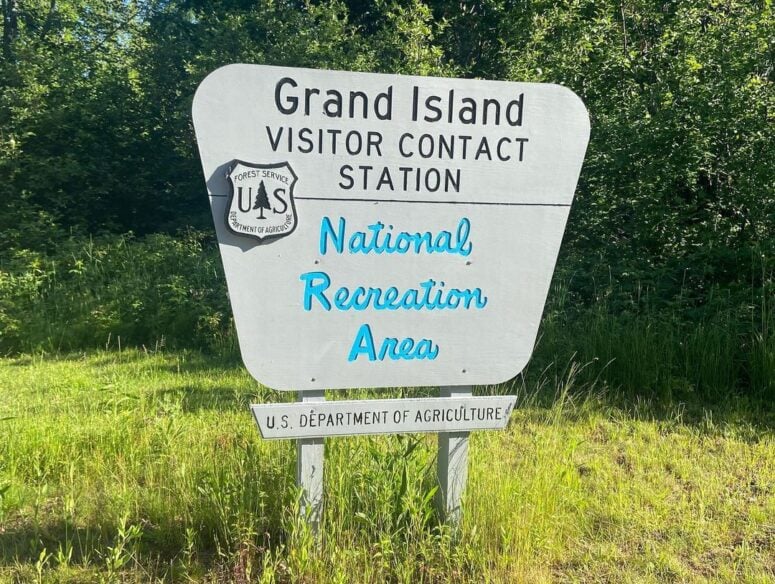
Grand Island
Grand Island is located in Lake Superior, just off the shore of Munising. It is part of the Hiawatha National Forest and is managed by the United States Forest Service. Known for its stunning natural beauty, rich history, and diverse recreational opportunities, Grand Island offers visitors a unique wilderness experience.
Natural Beauty
The island features majestic cliffs, sandy beaches, deep woods, and scenic overlooks with breathtaking views of Lake Superior. The varied landscapes make it a photographer’s paradise and a haven for nature enthusiasts.
Historical Significance
Grand Island has a rich history, from Native American use to European exploration and settlement. The island has remnants of old homesteads, cemeteries, and historic buildings that tell the story of its past inhabitants.
Recreational Activities
Visitors to Grand Island can enjoy biking, hiking, camping, kayaking, and fishing. The island has numerous trails, including a perimeter trail that offers a challenging bike ride or hike with stunning views of Lake Superior. There are also several rustic campsites for those wishing to stay overnight.
Grand Island National Recreation Area
This designation covers the entire island, emphasizing its importance for recreation, conservation, and natural beauty. The area is managed with a focus on preserving its natural character while allowing for public enjoyment and education.
 Narnia Trail | photo via _kellybird_
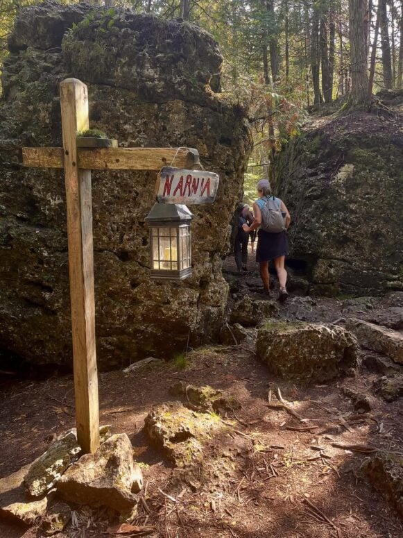 Narnia Trail | photo via _kellybird_
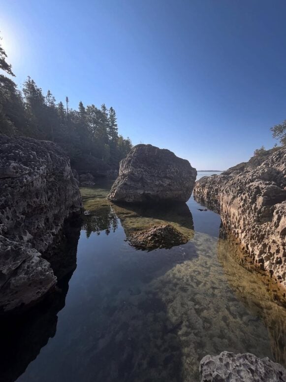 Narnia Trail | photo via _kellybird_
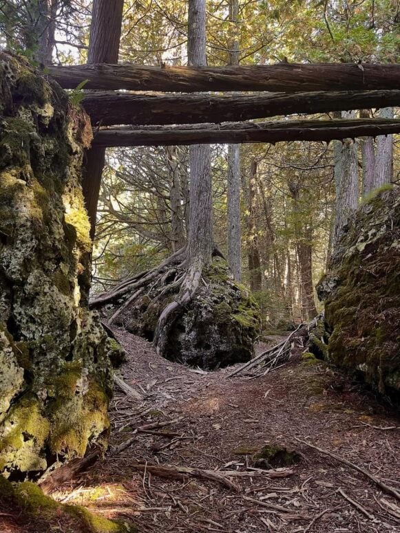 Narnia Trail | photo via _kellybird_
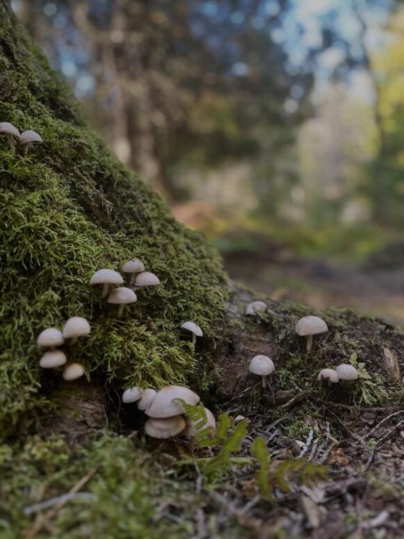 Narnia Trail | photo via _kellybird_
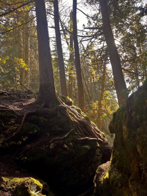
Narnia Trail
The “Narnia Trail” near Cedarville, offers a captivating hiking experience that ignites the imagination and delights the senses. Located at the southeastern tip of the Upper Peninsula, this trail provides a magical journey through the enchanting landscapes along the shores of Lake Huron, with the beautiful Les Cheneaux Islands as its backdrop.
Getting There
The trail’s entrance is east of Cedarville. Drive approximately 7 miles east on M-134 to the Woollam Preserve right before Prentiss Bay and the entrance to Cedar Bay Camp.
Distance and Difficulty
The trail spans approximately 2.1 miles one way, making for a 4.2-mile round-trip adventure. It is rated as easy to moderate, making it suitable for families with children. The path includes some exposed roots and wet rocks, with red arrow signs guiding the way.
Scenery and Attractions
As you traverse this special trail, you’ll encounter moss-covered rocks, mushrooms peeking out from under logs, and unique boulders about a mile in. The trail runs through a forest, offering serene views of Lake Huron and the opportunity to play among the boulders and relax by the lakeside. Don’t miss the iconic lamppost at the trail’s end, reminiscent of the entrance to Narnia itself.
Additional Hiking Options
For those seeking a longer hike, the John Arthur Woollam Preserve, connected to the Narnia Trail, features two more trails: the Woollam Preserve Loop (4.3 miles) and the Sandy Cove Loop, both showcasing stunning scenery along Lake Huron.

Wolf Mountain
Wolf Mountain is a true hidden gem near Wakefield in the Ottawa National Forest.
The trailhead is located at the end of Forest Road 9300 off US Hwy 2 between Wakefield and Marenisco. The hike is under a mile long but is a very steep climb to the summit.
It’s a beautiful hike any time of year, but in the fall it turns into a bright burst of colors!

More Hidden Gems to Discover in the U.P.
Other U.P. destinations mentioned included Crisp Point, Whitefish Point, Kitch-iti-kipi, The Porkies, and Isle Royale National Park. While each of these Upper Peninsula attractions is worth the trek, they’re not as “hidden” as the ones above.
Do you have a favorite hidden gem in the Upper Peninsula? Where should we explore next?
Well done!