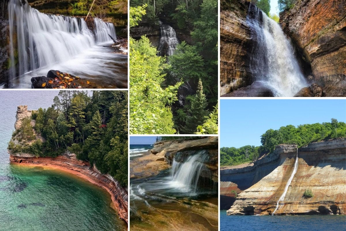
8 Pictured Rocks Waterfalls You Don’t Want to Miss
Would you like to save this full guide?
The beaches and sandstone cliffs of Pictured Rocks National Lakeshore have been carved out by Lake Superior, creating one of the most gorgeous places to visit in the Upper Peninsula of Michigan and the country.
However, some of the best sightseeing opportunities in the park are the Pictured Rocks waterfalls. In fact, the UP has at least 150 waterfalls, and several of them are within Pictured Rocks.
As one of our favorite places to visit in the summer, we’ve put together two hiking routes to six waterfalls, as well as some beach areas and other sites. We even have a suggested boat tour that takes you along the UP shoreline of Lake Superior to see the cliffs and more waterfalls.

Hiking to Miners Falls, Elliot Falls, & Munising Falls
Our itinerary for visiting Miners Falls, Elliot Falls, and Munising Falls is an all-day affair. But you can shorten or lengthen it as you like. If you follow this whole itinerary, pack a picnic lunch and plenty of water to stay hydrated.
Miners Falls
From the Log Cabin Retreat, take H-58 west to Miners Castle Road and then to Miners Falls Road, at the end of which is a parking area. The round-trip hike to and back from Miners Falls is 1.2 miles and takes about 25 minutes.
Tip: Miners Falls can get crowded on weekends, so go on a weekday if you want to avoid too many people.
The path is dirt and gravel and leads through the woods to two overlooks. The upper platform offers a view of the 50-foot waterfall and Miners Basin. You can take the 64 steps down to the lower platform for a different perspective of the falls.

Miners Castle Point
When you return to your car, you’ll get back on Miners Castle Road and follow it to the end where there’s a parking lot at Miners Castle Point. This area is one of the most famous along the Pictured Rocks shoreline and the only cliff area that you can access by vehicle.
You can follow the short, paved trail past interpretive exhibits to the upper and lower overlooks of Grand Island and Lake Superior. You get the best view of the sandstone cliffs in the distance from the lower outlook.

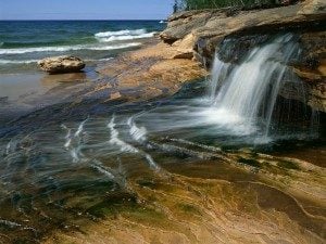
Miners Beach & Elliot Falls
Just to the east of Miners Castle is Miners Beach, a nearly 1-mile stretch of sand that you can access via the North Country National Scenic Trail (NCNST).
There’s a boardwalk on the west side of the beach, while Elliot Falls is in the eastern corner. This waterfall has two drops of only 3 or 4 feet, but the beautiful scenery makes people come back.

Munising Falls
Next, you can head southwest on the NCNST toward Munising Falls. Since this trek is about 7 miles or 2.5 hours each way, you could have your picnic beforehand in the picnic area at Miners Beach. If you want to wait, you can picnic when you get to Munising Falls.
The NCNST is the longest National Trail System at 4,700 miles long. During this part of your journey, though, you’ll only hike part of the Central Upper Peninsula section. Along the way, you’ll have dozens of photo opportunities of Lake Superior and the shoreline.
About 5 miles into the hike, you’ll pass Sand Point, which you can access via the Sand Point Marsh Trail. The beach here is popular for sunbathing and watching sunsets. It’s also the location of the park’s headquarters.
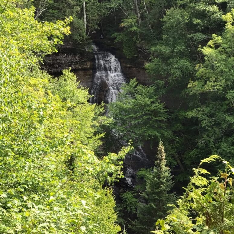
To reach Munising Falls, follow the 800-foot, paved and shaded trail along Munising Creek. It takes you to the base of the 50-foot waterfall, but there are two sets of stairs and platforms where you can get higher views.
The stairs aren’t too steep and provide great photo opportunities. You can actually walk very close to the falls. Because of rockfalls, though, the path behind the falls is closed to foot traffic.
This waterfall is within the city limits of Munising and is actually across the street from the municipal hospital. Fed by Munising Creek, the 50-foot Munising Falls drops over sandstone cliffs. It’s a very impressive waterfall and easy to access.
The Munising Falls Visitor Center is also here and has restrooms and exhibits. When you’re done exploring, follow the NCNST back to Miners Castle where you parked.
To get to the falls: From downtown Munising, take H-58 east to Washington St. Then, turn onto Sand Point Rd where you’ll see signs for the visitor center and parking lot. It’s less than a 5-minute drive from downtown!

Taking the Scenic Route to Spectacle Falls, Mosquito Falls, & Chapel Falls
It’s possible to see Spectacle Falls, Mosquito Falls, and Chapel Falls in just a couple of hours if you park in the lot at the end of Chapel Road. From the Log Cabin Retreat, the parking lot is about a 20-minute drive northeast. The trailhead there directly accesses all three waterfalls.
On the other hand, you could spend the day trekking the NCNST from Miners Castle, hiking along the Lake Superior shoreline. This time, though, you’ll follow the trail northeast and past Miners Beach. Again, we recommend packing a picnic lunch and plenty of water because this journey will take several hours.
The hike to Mosquito Falls is about 5.5 miles and takes about 2 hours. Around 4 miles into the trail, you’ll see the sandy Mosquito Beach at the mouth of the Mosquito River. Beside the beach are beautifully sculpted sandstone terraces that rise into higher cliffs.
As you follow the side trail and cross the Mosquito River, you should see Spectacle Falls to the side. Then, you’ll reach the 8-foot Mosquito Falls shortly after.
TIP: If you continue past Mosquito Falls, you’ll come to the smaller Spectacle Falls near a second wooden bridge.
Continue following the trail over the river again, over Chapel Creek, and then past the Chapel Road parking lot. The path passes over more water before it comes to Chapel Falls.
One of the unique things about Chapel Falls is that you can walk over, around, and behind it for multiple excellent views.
In total, the trail between the two falls is about 2.5 miles and takes almost 1 hour to hike. There are two viewing platforms with scenic views of the Chapel Basin and the 60-foot waterfall.
If you want to continue the adventure, follow the trail for almost 2.5 miles and about 45 minutes to the famous Chapel Rock and Chapel Beach. High bluffs stand around the picturesque, sandy beach at the mouth of the Chapel River.


Viewing Bridalveil Falls & Spray Falls From Lake Superior
Pictured Rocks National Lakeshore has two more waterfalls to see, and these might be the most exquisite. Although you can reach them while hiking, the best way to see them is from the lake.
For instance, you pass over the top of Bridalveil Falls on the NCNST to Mosquito Beach, and you can see it from afar on the lower overlook at Miners Castle. Also, Spray Falls is located about 2 miles northeast of Chapel Beach via the NCNST.
Bridalveil Falls has the distinction of being the tallest waterfall in the Pictured Rocks National Lakeshore, and it’s often used in advertisements. Although the water flow may only be a trickle during summer, it’s much heavier during the spring.
Since there’s no good viewpoint of Bridalveil Falls from the North Country Trail, the best places with a distant view are the Lower Miners Castle overlook and the far west side of Miners Beach.
No matter your point of view, seeing the lacy-looking falls plunge 140 feet down the rock face and into Lake Superior is totally worth it!
Instead, we suggest taking a tour with Pictured Rocks Cruises, the park’s authorized concessionaire. The tour boat company is less than a 15-minute drive from the Log Cabin Retreat.
To see both of these Upper Peninsula waterfalls, choose the more than 2-hour Spray Falls Cruise on a high-speed catamaran. It goes down the shoreline to the waterfall, giving you numerous opportunities for pictures — East Channel Lighthouse, Lovers’ Leap, Grand Portal, Chapel Rock, and more.
Spray Falls plunges 70 feet directly into Lake Superior. It’s in a category of its own when it comes to Pictured Rocks waterfalls.
You can get even more picturesque photos during the Sunset Spray Falls Cruise.


Dining Out in Shingleton & Munising
While the Log Cabin Retreat features an outstanding full kitchen, you might want to treat yourself to a meal or two out.
In Munising, the Falling Rock Cafe & Bookstore serves delicious coffee drinks made with custom-roasted beans. The cafe has tea, cold drinks, ice cream, and other desserts as well. Additionally, you can order specialty items, such as a mixed berry smoothie, smoked whitefish, and a grilled cheese sandwich.
Located at Roam Inn in Munising, Tracey’s is a casual restaurant that focuses on creating eclectic fare with an upscale presentation. It serves craft UP-style small plates, entrees, and beer.
Also in Munising, Miners Pasties and Ice Cream is in the perfect spot for grabbing a bite to eat before or after a Pictured Rocks Cruises tour (it’s right across the street). The Yooper and Vegan pasties are the main options, but it always has a breakfast pasty.
What makes Miners Pasties and Ice Cream stand out is the ice cream from Chocolate Shoppe Ice Cream Company. The portion sizes are very generous, and the flavors are unique — carrot mango Italian ice, root beer float, peanut butter, caffeinated chocolate, and loaded French toast to name a few. It has dairy-free options and lists allergens too.

Staying at the Log Cabin Retreat
The highlight of our itinerary is staying at the Log Cabin Retreat in Shingleton, just outside of Pictured Rocks and Munising. This place is amazing and has been featured on the Discovery Channel!
Located just off H-28 next to Haywire Trail 8, the Log Cabin Retreat is within a 20-minute drive of the landmarks, boat tours, and restaurants above. If you watch the Discovery Channel, you may have seen the cabin featured on the “Epic Mancave Builds” reality makeover show. The transformation was spectacular, and you can make it your UP lodging this summer.
The cabin is nestled on 20 acres of private property, surrounded by thousands of acres of Hiawatha National Forest. With 10 beds across a loft and 4 bedrooms, it can comfortably accommodate 16 guests. This makes the cabin wonderful for large retreats, family reunions, or special occasions.
The first thing that you’ll notice about the Log Cabin Retreat is the carefully chosen decor. It resonates with the feeling of camping in the woods, but you have all the comforts of home. In the kitchen, bar, and living room, you have everything that you need to cook, relax, and have a good time.
If you like ping pong, get competitive on the provided table. There’s even a deck, gas grill, and a fire pit for roasting marshmallows. In addition, you can enjoy ATV riding, mountain biking, and fishing on the property and surrounding trails. The large driveway is ideal for parking and maneuvering multiple vehicles and trailers.
Since the Log Cabin Retreat is famous and highly rated among rental lodgings, it can fill up quickly in the summer. We suggest booking your stay now so that you don’t miss out!