
Visit Mount Arvon – Michigan’s Highest Point
Would you like to save this full guide?
A must-see part of the Huron Mountains in Michigan’s Upper Peninsula, Mount Arvon is Michigan’s highest point. Rising 1,979 feet above sea level and fairly accessible by most vehicles, the summit of Mount Arvon is definitely worth checking out.

Mount Arvon Facts – All About the Tallest Mountain in Michigan
Where in Michigan is Mount Arvon?
Mt. Arvon is located in Michigan’s Upper Peninsula in beautiful Baraga County, in the Huron Mountain Range, and is approximately 27 miles from L’Anse, Michigan.
Is Mt. Arvon Michigan’s Highest Point?
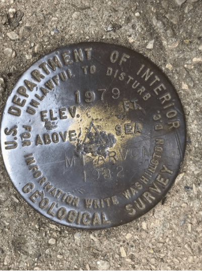
Mt. Arvon has been recognized as the highest point in Michigan since 1982. Prior to 1982, the highest elevation in Michigan was Mount Curwood at 1978 ft.
The survey done that year by the US Geological Survey found Mt. Arvon to be a mere 11 inches taller than Mt. Curwood, naming it the highest point in Michigan. It is still disputed which is taller, and some maps of Michigan still incorrectly label Curwood as the highest point in the state.
How Tall is Mount Arvon?
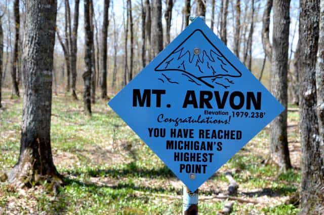
At 1,979.238 feet above sea level, Mt. Arvon is Michigan’s highest point.
Is Mount Arvon a True Mountain?
Apparently, geologists get to decide what is a mountain and what is not a mountain. And from what we’ve heard, geologists say that a mountain is anything over 2,000 feet above sea level. Of course, this leaves poor Mount Arvon a measly 21 feet short of true “mountain” status.
Well, Mount Arvon, you’re still a mountain to us, and we’ll happily climb to your summit any day!
What is White Tape?
You may have heard about “white tape” in reference to being able to access Mount Arvon. White Tape refers to the restrictions mother nature places during the region’s longest season – winter. When there is snow on the ground, the only access to the summit of Mount Arvon is via snowmobile or snowshoes.
How To Get to Mount Arvon
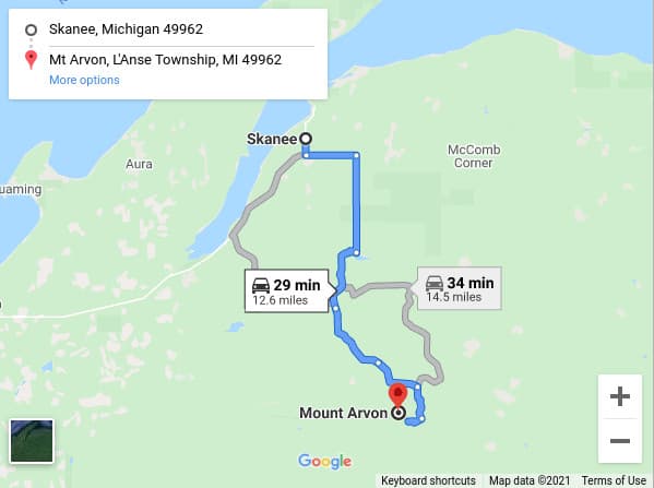
To visit this unforgettable peak, make your way to the community of L’anse and venture up a rustic but beautiful gravel roadway toward the top of Mount Arvon. You drive through L’Anse, take a trip down Skanee Road, then turn onto what shortly becomes a gravel road. Eleven curvy miles later you reach the top of Mount Arvon.
This highest point in Michigan, Mount Arvon, is located in very rural northern Michigan, with the closest small town being the quaint waterfront town of Skanee.

The Road to Mt. Arvon
Not long ago Mt. Arvon had the reputation of being one of the most difficult state highpoints to reach due to its remoteness and the maze of logging roads one was required to travel to reach the summit.
In the past few years, however many improvements have been made both to the road leading to the summit and the parking area near the top. The road to Mount Arvon is windy and a bit bumpy, but is drivable if you use caution.
The road is now well-graded and numerous blue signs along the way help keep you on the right track on your way up the mountain. The road still is steep and rocky in a few sections, mainly within the last 2 miles, but can be carefully traveled by most passenger vehicles.
The road to Mount Arvon is a windy gravel road that’s often used for logging and is often very rough in spots. If you chose to visit, we’d recommend taking a vehicle with high ground clearance.
I wouldn’t say you need four-wheel drive (as long as the road is dry) but there are a few ruts and rocks here and there that could very likely cause a standard passenger car to bottom out or blow a tire.
Also, the road gets fairly narrow toward the top to the point where if you meet another car and have to pull off the road a bit, you may want something a little beefier than a Camry.
The roads are often muddy during the rainy season, making them unsuitable for passenger cars, and in the winter months, Mount Arvon is only accessible by snowmobile or snowshoe, as the road is not plowed.
– Jesse Land, Awesome Mitten’s Resident Yooper
Driving Directions to Mount Arvon
- From the intersection of US 41 and Broad Street in L’Anse, drive north into L’Anse on Broad Street for .7 miles until you reach Main Street.
- Turn right (East) on Main Street, which becomes Skanee Road, and continue 16.1 miles to Roland Lake Road.
- Turn right by the large Zion Lutheran Church, and drive 2.9 miles to where the road comes to a T.
- Turn right at the T onto “Ravine River Road” and follow the blue signs (mostly just small blue arrows) to the top of Mount Arvon.
There are some smaller dirt roads that branch off from the main road, so be sure to continue to follow the main dirt road, and watch for the blue signs marked on the trees along the road. The road is very well marked. Either a sign or a small blue arrow marks each place where the road splits to keep you on track. (Be sure to follow the blue signs!)
The gravel pit parking lot near the top of Mount Arvon was added in 2012 and the road up the mountain has been improved.

Can You Climb Mount Arvon?
You won’t find Mount Arvon listed in many Michigan tour books, despite its official designation as the highest point in the state. But more and more, Mount Arvon in the western Upper Peninsula is getting attention and drawing people to visit in an attempt to climb Michigan’s highest mountain.
According to savethehuronmountains.org, Tracey Barrett, director of the Baraga County Convention & Visitors Bureau in L’Anse, hikes to the summit nearly a dozen times a year:
“It’s a cool place to go. There’s a view of Lake Superior and Point Abbaye. It’s really pretty, really remote.” Mount Arvon, which is in L’Anse Township, is a 27-mile drive east from the village of L’Anse, Barrett said, and “years ago, there was hardly a road” to the peak and is appreciative of the road and hiking trail now available.
Hiking Mount Arvon
The “fairly wide level trail” leading 1/2-mile from the parking lot to the summit of Mount Arvon has changed. The 1/2-mile jaunt is a drivable unpaved road leading to an open parking area next to the summit entrance.
The hiking trail is marked with blue diamonds painted on the trees with a few other sign-age for guidance.
Pro Tip: Be sure to check the beaver pond about a 1/2-mile from the top of the summit for moose.
A person now only needs to walk about 40 feet into the trees to reach the summit with no elevation gain on foot, making it more accessible to people of all abilities.

The View from the Top of Mt. Arvon
There didn’t use to be much to see at the top of Mt. Arvon, but now a few trees have been cleared and if the weather on Mount Arvon is agreeable and clear, you can enjoy a beautiful view of Lake Superior and the Huron Islands.
On Top of Mount Arvon – Michigan’s Highest Point
When you reach the top of Mount Arvon, there’s a sign noting that you are in fact at the top of Michigan’s Highest Point. There’s also a picnic table, a fire pit, and a mailbox.

The mailbox on Mount Arvon contains a book for you to sign your name, where you’re from, and when you visited. It’s pretty cool to flip back a few pages and see all the different people from all over the place that have been here.
There’s even a group of people called the High Pointers Club that is all about reaching the highest point in each state, and you are likely to see an “HP” with a number next to names signifying the number of “high points” that individual has reached.

Jesse’s Mount Arvon Experience
Our resident Yooper, Jesse Land, “climbed Mount Arvon” and shared his experience with us…
I visited Mount Arvon on my way back from camping at Big Eric’s Bridge State Campground and exploring the mouth of the Huron River. I honestly expected it to take a little longer than it did and was surprised at how little time this side excursion added to my trip back home.
The eleven-mile drive from Skanee Road to the summit took about half an hour because I took it easy and stopped to check out a cool little roadside waterfall. I met two cars on my way up, but once I reached the top I had the place to myself.
There’s a good size parking area at the top and then there’s that clearing I mentioned above that gives you a great view of the lake and a couple of islands. With the grill and the picnic table right there, I sort of wished I’d carved out more time for this stop. It would have been cool to fire up the grill and have a cookout at Michigan’s highest point. Next time!
At any rate, the drive down was uneventful. I made it back to Skanee Road in about twenty minutes and then continued onto L’Anse to grab a coffee at Java by the Bay.
Have you ever been to Michigan’s highest point? Is Mt. Arvon on your Michigan bucket list?
Unofficially, as apparently Michiganders aren’t so proud of the fact, the mining waste heap in Ishpeming is the tallest point in the state.
Man-made “mountains” are mountains too. ?✌️
Michigan’s lowest point is the mining pit less than a mile from the highest point.
When you summit Mount Arvon, be sure to bring a stone with you and we’ll all start a stack at the peak and perhaps Mount arvon can truly one day once again be the highest point in Michigan.